Thingvellir is the rare place where a nation’s origin story is written straight into the landscape. Here, Iceland’s first general assembly – Alþingi, founded around 930 – met in the shadow of cliffs that mark the boundary between two tectonic plates. A thousand years of law, trade, and tradition unfolded beside a valley that is literally being pulled apart. Recognized by UNESCO for its outstanding cultural value, Thingvellir lets you experience Icelandic history and active geology in a single walk.
Why visit Thingvellir?
Walk between continents
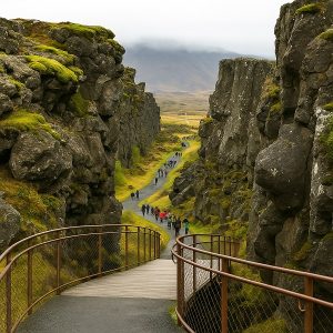
Follow boardwalks through Almannagjá gorge, a dramatic tear in the earth created by the separation of the North American and Eurasian plates. The scale is obvious underfoot and on the canyon walls – no classroom explanation required.
A compact, easy-to-plan visit
The park’s main sights—Hakið viewpoint, Almannagjá, Lögberg, and Öxarárfoss—link together on well-signed paths, making a memorable loop you can do in 1–2 hours.
Stand where a democracy began
At Lögberg (Law Rock), chieftains and speakers gathered to make laws, settle disputes, and shape a society that still traces its roots to this open-air parliament. Thingvellir also hosted the 1944 proclamation of the Republic of Iceland, tying medieval heritage to modern nationhood.
Photogenic in every season
Summer brings green moss and long light; winter dusts the rift and lava with snow, highlighting textures and contrasts. Sunrise and late-day light are especially rewarding.
World-class freshwater clarity
Silfra, a water-filled fissure between the plates, offers guided snorkeling and diving in exceptionally clear glacial spring water filtered through volcanic rock. Even if you stay dry, viewpoints let you appreciate the fissure’s vivid blues from above.
Close to Reykjavík, perfect for the Golden Circle
Less than an hour from the capital and naturally paired with Geysir and Gullfoss, it’s an essential first stop that frames the rest of your Iceland journey—history, geology, and scenery all in one.
Quick Facts
Highlights & What to See
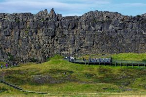
Almannagjá Gorge
Follow the boardwalk from Hakið down into Almannagjá—the clearest, most accessible place to “walk between continents.” The path is mostly level once you’re in the gorge, with interpretive panels that explain the geology and the assembly site. Expect spray and wind funneled by the cliffs; in winter, packed snow/ice can linger, so traction aids are smart. This section links easily to Lögberg and onward to Öxarárfoss.
Lögberg (Law Rock)
A short stroll from the gorge brings you to Lögberg, the focus of Iceland’s early parliament. Panels outline how the Lawspeaker addressed the gathering and how disputes were settled here for centuries. Spend a moment to read the markers—this is where the place-name “Þingvellir” (“fields of parliament”) comes alive. It’s also a natural pause point for wide shots back toward the gorge.
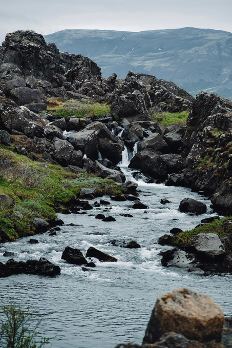
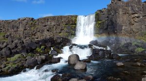
Öxarárfoss
Tucked in a side fissure, Öxarárfoss is compact but dramatic, framed by dark basalt and often rimmed with ice in colder months. Most visitors reach it as a loop from Hakið via Lögberg, or more directly from P2 (Efri-Vellir). The spray can be noticeable on windy days—pack a lens cloth. Best photos come from a low angle near the footbridge; in winter, expect slippery approaches.
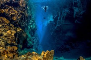
Silfra Fissure
Silfra is a water-filled rift famous for its crystalline blues and underwater visibility. Even if you’re not diving or snorkeling, you can view the fissure and watch guided groups kit up near P5 (Valhöll) by the church area. Above-water, the color contrast is striking on bright days; below-water access is by guided tour only and covered in the “Silfra: Snorkeling & Diving” section. If you’re staying topside, allow 10–15 minutes to wander the paths and viewpoints along the shore.
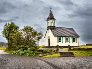
Þingvallakirkja (Church)
This small, historic church anchors the old assembly plain and is typically open in summer when a ranger is present. The setting is serene, with turf-lined paths, simple graves, and views across meadows to the lake. It pairs naturally with a stop at Silfra nearby, and it’s a gentle, reflective counterpoint to the grand geology elsewhere in the park. Respect posted opening times and keep voices low inside.
Best time to visit
- Summer (Jun–Aug): Long days, easy walking, green landscapes.
- Shoulder (May, Sep–Oct): Balanced light, fewer crowds.
- Winter (Nov–Mar): Snow-dusted rift; bring micro-spikes if paths are icy; pair with Northern Lights chasing.
Facilities
- Visitor Centre at Hakið (exhibition, info, restrooms; shop/café hours vary by season).
- Wayfinding boards and time estimates on main routes.
Accessibility & Safety
- Boardwalks and compact paths near Hakið/Almannagjá; elsewhere can be uneven.
- Respect footpath closures in icy/windy conditions.
- Weather changes fast—pack layers and waterproofs.
History in 6 Lines
874 – Norse settlement begins
Ingólfur Arnarson’s arrival marks the start of Iceland’s settlement era (~56 years). Independent chieftaincies spread around the coast, sharing language and custom but lacking a single authority—setting the stage for a common assembly inland at Þingvellir.
930 – Alþingi founded at Lögberg
Representatives gathered at Lögberg (Law Rock) to recite laws, settle disputes, and forge a legal framework for a scattered society. The open-air setting, natural acoustics, and central location made Þingvellir the ideal national meeting ground.
1000 – Conversion to Christianity
Amid regional pressure and internal division, the assembly chose a single faith to avoid civil strife. Tradition holds the decision was brokered at Lögberg, demonstrating the Alþingi’s role as a practical peacekeeper as much as a law court.
1930 – National park designation
On the Alþingi’s millennium, Þingvellir became one of Iceland’s first protected areas, safeguarding both the assembly plain and the rift-valley landscape for future generations.
1799–1844 – Alþingi suspended, then restored
Under Danish rule the parliament paused; when it returned, it was re-established in Reykjavík under the same historic name. Þingvellir remained the symbolic birthplace—its fields preserving the memory of the original assembly site.
1944 – Republic proclaimed
In a moment that linked medieval tradition to modern statehood, Icelanders gathered at Þingvellir to declare the republic and confirm the first president.
Geology at a Glance
Rift setting: Iceland straddles the Mid-Atlantic Rift; Þingvellir lies between the North American and Eurasian plates.
Rate of spread: The plates separate by roughly ~2.5 cm per year, accumulating over millennia.
Almannagjá: The clearest place to feel the rift—walk beneath the cliffs and along fissures like Flosagjá.
What you’ll notice:
Lava fields that filled space as the rift opened, numerous ravines from past quakes, and a valley that’s slowly subsiding. Micro-earthquakes occur frequently, though most are too small to feel.
Wildlife & Fishing
Birdlife
Thingvellir is great for casual birding in summer. Along river edges, wetlands, and the shores of Þingvallavatn you’ll see dabbling and diving ducks, waders, and summer songbirds. Regulars include golden plover, common snipe, and several duck species; keep an eye out for specialty ducks on the lake and for raptors riding the thermals on clear days. Best viewing is early morning and late afternoon when winds drop and activity spikes—bring binoculars and a 300 mm lens if you shoot.
Mammals
Native Arctic fox are occasional, mostly at quieter hours; if you’re lucky, you’ll glimpse one crossing open ground at dawn or dusk. American mink (an introduced species) sometimes patrol streams and lake margins. As always, observe quietly and give wildlife space – no feeding or calling.